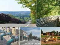
- Community
-
- About Sherwood Sherwood Heritage Center Chamber of Commerce Marjorie Stewart Center Sherwood Center for the Arts Sherwood YMCA Family Resources
- Events and Activities City Calendar Library Events Community Events Event Permits Monument Posting Request Community Meeting Rooms Recreation Parks and Trails Directory Recreation Programs Sherwood Fieldhouse
- Community Field House Sherwood Demographics Sherwood School District Sherwood Youth Sports Utilities Volunteer Opportunities Highway 99 Pedestrian Crossing Public Safety Police Tualatin Valley Fire & Rescue
-
- Business & Development
- Government
-
- City Council Boards and Committees Urban Renewal Agency Agendas and Minutes Municipal Code Public Records
- Building City Attorney City Manager Code Compliance Community Development Community Services Economic Development Emergency Management Engineering
- Finance Human Resources Library Municipal Court Parks & Recreation Planning Police Public Works Utility Billing
-
- Online Services
-
- Job Opportunities Utility Billing Alerts & Notifications Email Subscriptions Sherwood Flash Alert Police Flash Alert Events and Meetings Agendas and Minutes Calendar
- Contact the City Submit a Request or Concern City Offices Municipal Code Documents and Forms Documents and Reports Forms and Applications
- Social Media
-
Long Range Planning

Long range planning is the planning process that looks to the future Sherwood. We know that Sherwood will grow and change over time. We ask our local community to take a look a the what Sherwood has currently in the way of people, jobs, and infrastructure and help us identify where and how new residents will live, work and play. We work on developing long range plans for areas within our current boundary and areas identified to be within our city limits in the future. These plans help us determine what the land use will be and what infrastructure (like roads, water and utilities) will be needed in the future. This is based on what our community both values and needs and how to serve the growing community.

The Sherwood City Council adopted Ordinance No. 2021-011 which adopted the Economic Opportunities Analysis (EOA) for Statewide Goal 9 compliance as a supporting document to the City’s Comprehensive Plan on December 7, 2021.
COMPREHENSIVE PLAN AND ADOPTION PROCESS
Like all cities in Oregon, we must plan for current and future generations. We know that communities that plan for growth have the best chance of managing their destiny in a way that retains the qualities that brought us here in the first place: our small-town character, forests and farms, excellent schools, thriving businesses, and parks, and public spaces.

About the Project
The City of Sherwood is undertaking a development code audit and needed development code amendments to support a range of community housing choices. The development code audit project aims to understand the existing barriers and future solutions to promote a larger supply of housing options for the community. Amendments to the development code will provide an opportunity for a variety of housing types at various price points community members at different stages of life such as
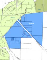
In 2002, Metro Ordinance 02-986A added 33 acres north of Tualatin-Sherwood Road to the regional urban growth boundary (UGB). Metro’s primary purpose was to allow for development of a road connection (Adams Avenue) between 99W and SW Tualatin Sherwood Road. Before a road can be constructed however, the area must be concept planned (identify what the zoning should be and generally how the area should develop) and the road designed.
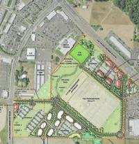
Area 59 is an area that was designated by Metro and brought into the Sherwood UGB in 2002. Metro required local jurisdictions to develop a concept plan for this area bordered on Elwert and Edy Rd. before annexation and development of any property. After 2 years of public involvement a concept plan was adopted by City Council in April 2006. In January 2007, the Council adopted amendments to the Comprehensive Plan to implement the concept plan.
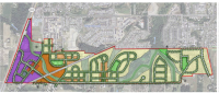
The City worked for over a year to develop the concept plan for the “Brookman Road Concept Plan.” This area was brought into the Urban Growth Boundary by Metro in 2002 in order to accommodate an identified region wide need for additional land. The Concept Plan study area boundaries include the existing city limits to the north, Brookman Road to the south, Highway 99W to the west, and properties located due east of Ladd Hill Road.

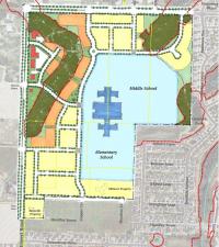
The SE Sherwood Master Plan was not formally adopted by City Council. This plan is available for information only.
Master Plans generally guide development over the next five to twenty years. They translate the broad, long-term strategies of the Comprehensive Plan into detailed plans for implementation by specifying long range goals and capital improvement projects.
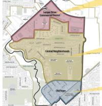
A “Town Center” is a designation of a place that our regional government, Metro, categorizes as the center of activity for a community. To give you some background, “town centers provide localized services to tens of thousands of people within a two- to three-mile radius.” Examples include small city centers such as Lake Oswego, Tualatin, West Linn, Forest Grove and Milwaukie and large neighborhood centers such as Hillsdale, St. Johns, Cedar Mill and Aloha. Town centers have a strong sense of community identity and people can travel by foot easily and access transit.
The Southwest Corridor Plan is a comprehensive planning effort to help address the impacts of future growth while preserving great neighborhoods and creating more great places. It is a collaborative planning effort with Metro and local jurisdictions within the southwest Portland metropolitan region including Portland, Tigard, King City, Tualatin, Sherwood, and Oregon Department of Transportation.
The City Council adopted the final concept plan for the Tonquin Employment Area on October 5, 2010. The approved concept plan can be found by clicking the links below. Properties within the Tonquin Employment Area may now be annexed into the City of Sherwood. Upon annexation, the properties will be zoned Employment Industrial (EI).
Questions? Contact Planning Staff at 503.925.2308.


